#GeoEdChat Think Piece from David Rogers

How do you assess the development of geographic skills?

Progress and Achievement


Before you start, my aim with this post is to provoke and ask more questions.  I’m not an expert, and I don’t even have a beard….

We all work within the confines of formal examination systems, but how do you develop geographical skills as well as knowledge and understanding?  If you choose to develop skills, which skills are developed?  What are the informed by? Why those skills?  How do you identify and measure skill progression?  How are these skills taught – in isolation or embedded within a geographical context?

These questions go to the heart of what it is that makes a good geographer. In my view, the teaching of irrelevant or poorly defined skills or skills constrained toward examination technique only, are responsible for much of the bad geography lessons I have seen over the past five years.  I think that it is vital to teach skills alongside content, but how should this be done and how can it be measured?

We had the Personal Learning and Thinking Skills framework in the UK but skills without a strong geographical context is the wrong approach.  Why subject children to a ‘map skills’ unit when map skills can be developed in other ways?

Are there any skills that uniquely geographical?  We improved the quality of geographical writing at Priory by teaching in the same way as English colleagues – using the same rules and techniques. Therefore, should geography departments be making links to other parts of the curriculum to enable children move away from assimilative learning, which they then struggle to apply to other disciplines, toward transcendent learning?  Should we as ‘teachers of children’ focus on furnishing our charges with the skills needed to succeed in later life rather than subject specific skills?

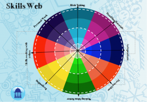
At my current school, the Art department are developing a skills web, a way in which to track skills development.  Colleagues at Priory Geography have also started the process of developing this skills web.  Consider the following – are they on the right lines?  What could be added?

Skills


Designed by Patcham High School’s Art Department

#GeoEdChat October 16th 2013: How can school grounds be used for teaching Geography?

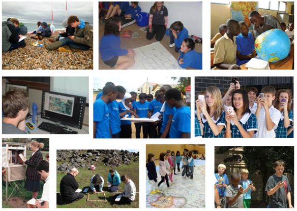
This post is a thinkpiece for #GeoEdChat to help people think of ways they have used or plan to use their school grounds to teach Geography. As Geographers we love working outside the classroom and believe in the power of this in aiding student learning. Along with the obvious examples of learning with field work, we often use the school grounds in creative ways.

Here are a few of the ways I have used the school grounds over the past 2 years:

  • Muriwai in chalkThe courtyard outside of our class was turned into our coastal environment and the students became the wave trains approaching the coast. In this way we were able to physically see the process of wave refraction occurring and discuss the reasons why to add depth to the annotated diagrams we drew in class.
  • Guerrilla LanguagesI have used Guerrilla Geography in many classes to get students thinking and provoking further thinking of others in the school. In the example shown in the photo above, this class had been studying Globalisation and were now sharing important messages about Globalisation that related to their lives at school. This activity had students working in groups, thinking of their audience and picking the important points out of their previous learning – a great revision exercise.
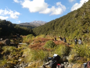
  • Mt Ruapehu

    Mt Ruapehu

    The school grounds are brilliant for preparing students for fieldwork activities. Before taking Year 12 Geography students to Tongariro National Park for their field research, we used the school grounds to train the students in their field procedures. Steve Smith has devised a series of activities to achieve this. Driveway slopes turn into quasi rivers to measure river velocity, gardens are great for Vegetation Transects and slopes overlooking the fields, perfect for slope profiles. Precis sketches are also very easy to practice by purely walking to a different part of the school and practising your sketches.

  • The final activity was one used for learning about perspectives. I had students all in one place writing a description of what they had seen. We then shared these descriptions and discussed how different people noticed different things from the exact same view. A great introduction for these students as to how perspectives shape our actions!

How do you use your school grounds to teach Geography?

Do these activities add anything to your classroom learning?

How do you know?

Love to hear your thoughts in #GeoEdChat at 8pm your local time on Wednesday 16th October.

#GeoEdChat is back from our hiatus

#GeoEdChat is back from our mid-year break!

We are moving back to a voting format where you get to choose the topic of the next chat so that the Chats are as relevant as possible for all Geography Teachers. The moderator will then post a thinkpiece on the chosen topic to help stir the conversation.

Come back in the next couple of days to see the poll for our first chat back!

#GeoEdChat Blog Share: Innovative Lessons

Something different this week for #GeoEdChat. On Wednesday we would like you to share a blogpost about an innovative lesson. Hopefully this will be a post from your blog about a lesson you are particularly proud of (good incentive to start a blog if you dont have one already!) or it could be a favourite post of someone elses.

At the end of the week I will write a post on here with links to all of these great Geography lessons so all can share and learn from them.

nb: if you have a protected account please make sure @GeoEdChat or @GeoMouldey are tagged in your tweet so that your blog can be included on the final summary

What aspect of Geography do students find most engaging?

This week’s question for #GeoEdChat comes courtesy of Rod Yule who asked a couple of #GeoEdChat participants what aspect of Geography that students found most engaging.

I had a whole range of answers to this question come flooding out:

  • Contexts that students find relevant to their lives
  • Changes each year depending on class interests – some years I have had big groups who are incredibly interested in environmental issues, other years groups that just want to do more physical geography
  • A common theme is that students need to see the authenticity of the content to be studied (this is fairly easy in Geography in my opinion), that is students want to see the real world relevance – that it is not just some made up problem
  • Something provocative that brings an emotive tug to what will be studied

Then I started thinking more and remembered a conversation that I had in my department last week. We were discussing results of students in exams and how many in the department consider themselves “physical geographers” but our students seem to do better in the “human” papers – Population Studies, Development Inequalities etc. This has been a common theme over a few years so is there something in these papers that particularly engages the students?

What aspect of your Geography course do students find most engaging?

Why do you think this is?

Do you regularly ask your students in a manner in which they can be completely honest?

#GeoEdChat 10 with Stephen Matthews (@srmdrummer): Are traditional #skills in geography still useful?

A variety of skills

Most geography educators would probably agree that skills are woven into the fabric of geography; skills in the classroom and skills in the field, as well as skills involved generally in geographical inquiry. Often, it is inquiry that is used to organise how skills are articulated in school geography, as seen for example, from National Geographic or in the newly released Australian Curriculum: Geography. In other places, skills are formed into lists or other categories in their own right, as for example, from the NZ Ministry of Education. Regardless of how they are organised, it would be fair to say that, across these categories of skills, we would encounter some skills that would be termed as ‘traditional’. This raises some questions:

  • What might be considered the traditional skills of geography?
  • Are these traditional skills as relevant and useful as they always have been?
  • Are the more contemporary skills that are emphasised today more about employing modern tools and technologies to do ‘traditional’ things?
  • Is there a case for ensuring that students are able to utilise traditional skills in the traditional, as well as contemporary ways?

There are some, however, who would argue that skills have been, or are overly-emphasised in some school curricula at the expense of other important aspects. When UK education secretary Michael Gove initiated the review of the National Curriculum a couple of years ago, he was critical of a “lack of facts and vital knowledge” in many areas of the curriculum. We might consider whether a focus on skills, especially when not in the context of content, a good idea? Does the ‘knowledge turn’ potentially affect the quality of skills teaching in geography?

As the Australian Curriculum: Geography* was under development, there was early criticism that skills at the primary level expected too much of essentially non-specialist teachers. More recently, questions have been raised about the lack of specificity in skills, with fieldwork and the sequential development of skills using geospatial technologies not technically included in the Curriculum’s mandatory ‘Content Descriptions’. This has undoubtedly come about because the Australian Curriculum, Reporting and Assessment Authority (ACARA) required inquiry and skills to be combined in a single strand with generic inquiry as the organising structure. Having said this, is there the risk of creating potentially vast ‘checklists’ of skills to be covered in a curriculum? Should choices about how and when particular skills are covered be left solely for teachers to determine?

Where, then is the balance in teaching skills in geography to be found? Traditional versus contemporary, stand-alone versus integrated, explicit versus implicit, and so on. Has geography moved past the need to teach traditional skills or are there other imperatives? Join us for the next #GeoEdChat to share your views on skills in geography via Twitter on Wednesday, 5 June, or if you can’t make it, leave your replies here.

(* Declaration: This blogger was involved as a writer of the Australian Curriculum: Geography but the views expressed here are his views are his own.)

#GeoEdChat 9: Cross Curricular Collaboration – Golden Opportunity or End of Specialism?

There is growing talk about collaboration between subjects in school. From what I see/read/hear there seems to be 2 schools of thought with a few ambivalents in the middle. The most vocal are those at each end of a spectrum ranging from ‘golden opportunity for amazing learning experiences’ to those who see it more as ‘crosscurricular mush causing the end of specialist knowledge.’

Recently, I enjoyed reading the experiences of Matt Podbury (@mattpodbury) and Jim Noble (@teachmaths) who worked together on a joint Geography and Maths project about population growth called World Village (and here). I encourage you to read these as I feel they capture the true essence of what crosscurricular projects can do. It is an authentic collaboration where they fit together naturally without any subject being forced to fit. The links provide an authentic learning experience that requires the specialist knowledge from both subjects.

There are, however, examples I have heard of where collaboration is forced and unnatural in projects and I have heard of people saying that they would not want to collaborate as it will cause a watering down of their subject knowledge.

My personal opinion is (not important, but for interest’s sake) that as Geography teachers we should be pursuing a more collaborative approach with other subjects. There are many issues and topics that we study where other discipline knowledge would help give students a deeper understanding. And that is what we should all be striving for after all.

So for #GeoEdChat:

  • Is collaboration a golden opportunity or the end of specialism?

#GeoEdChat 8 with @DanRavenEllison – How can #play be used to improve geographies?

There is a strong link between geography and play. Geography is simply a giant game of hide and seek. Mentally and physically we’ve always played the game. From our first smiles playing peekaboo to the war games (and battles in theatre) that are played out by our military and political leaders, much of our lives are spent searching, evading and finding.

Play can be a powerful way for us to learn about places. Indoor games like The Settler’s of Catan draw from the ‘real world’ and can be an engaging way for us to learn about trade, strategy, inequality and theory (as this game is based on Central Place Theory). With parallels to the famous Trading Game by Christian Aid, indoor (board)games are effective and largely uncontroversial learning tools. A good exception being those created by my good friends at Terrorbull Games (check out the print-and-play games).

Outdoor play is far more controversial than indoor play for some teachers, parents and communities. We all know about the concerns for ‘safety’, curriculum time and other barriers that prevent children from benefitting from outdoor play, learning and exploration. Countries like Scotland have a very forward thinking approach to outdoor learning, but in England, the United States, Australia and other ‘developed’ countries the picture is far more bleak. Despite a raft of evidence revealing the benefits of us (all) having time and space to playfully learn outdoors, too many children just don’t get the right opportunities.

There is much that the professional ‘geography’ and ‘play’ communities can learn from each other. Playworkers, play rangers and playground designers are all inherently interested in creating valuable, meaningful and appropriate places for children. As well as micro-play environments like sandpits, many people in this thriving community are working hard to change the geographies of their communities by creating play streets and helping parents to rethink the real geographies of risk in their local area. Equally, geography educators can learn much from the way that playworkers create opportunities for free play (and learning) and conceptualise how this play can be of benefit to us.

An ever increasing movement of individuals and organisations are working to help the gatekeepers unlock opportunities for us – not just the children – to spend more time exploring, playing and learning outdoors. My work with Mission:Explore, the programme by the John Muir Award, the awesome personal drive of Juliet Robertson with Creative STAR and campaigning by Play England are just tiny sample of what is happening in the UK.

Empty Classroom Day on Friday 5th July is one of the most exciting. It’s a simple idea and one that we should all support. It’s aim is simple – that every school in the UK (I reckon this should say on Earth) there will be an empty classroom and pupils will be learning in their playground, local park, farm, seaside and the great outdoors.

So, my question for #GeoEdChat this Wednesday is this. Given that Empty Classroom Day is just around the corner..

  • How can play be used to improve geographies?
  • What outdoor games can you recommend that help us to learn outdoors?
  • How can play improve the geography of your community?
  • What can you do to support Empty Classroom Day?

#GeoEdChat now takes place for 24 hours every Wednesday with a focussed meet-up at 8pm in your timezone. I’ll be dropping in and out of the chat all day. Tweet with you then?

@DanRavenEllison is a Guerrilla Geographer and National Geographic Emerging Explorer.  He is one of the people behind Mission:Explore, a project to inspire young people to explore, learn and play outdoors. You can follow his blog here.

#GeoEdChat 7 What is a Successful 21st Century Geographer?

There is a lot of talk and articles online about 21st Century Education and what this looks like in practice. There has also been big structural changes to Geography curriculums across many countries in recent years. Have the Geography teaching programs evolved with these changes so that we are creating successful 21st Century Geographers? Or are we still continuing to act like this:

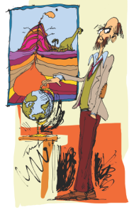
Old School Geographer by Tom Morgan-Jones

Old School Geographer by Tom Morgan-Jones


As many of these curriculum changes come into place it has been my experience that many teachers are looking at how much of their old teaching programs they are able to keep and just tweaking small amounts to say they have made the necessary changes. If this is the case (and Yes I am sticking my neck out here purposely to provoke discussion), are we adequately meeting the future needs of our students?

What are the skills that a person would need to be considered a successful Geographer in these dynamic times and into the future? (are these different than 5/10/20 years ago?)

Does your teaching program allow students to engage in depth with future focused issues with multiple perspectives? Are you teaching these issues in a way that relates them to your life or your students lives?

I argue that we should be changing our teaching programs allow students time to inquire into geographical issues with an emphasis on what these issues mean for the future. This way they will be able to contribute to dialogue in the community about their future. As a subject we are uniquely placed to help students engage with issues such as fracking, sustainability, development and globalisation. This to me would help produce a successful 21st Century Geographer – a person that understands the various perspectives held on controversial global issues and can work out how to take action so the future consequences are in the best possible balance. Yet how much of your teaching program is spent on these? How much of the time on these issues allows students to actually engage with them in depth? Are they exploring various perspectives and projecting future implications or are they merely scratching the surface of these issues?

What do you think a successful 21st century geographer should be able to do? How does your teaching program allow them to flourish?

We have evolved!

Hi all,

after our initial chats, we have had a short break to reflect on how we can improve #GeoEdChat and have come up with a few tweaks. This way we hope to engage more people with the ideas each week (and if you miss one you only have 1 week to wait!). The main change is a move from 1 hour only to a more informal day long affair.

How it will work:

  1. Blog – The guest moderator posts a “Think Piece” on this site
  2. Chat – #GeoEdChat on Twitter, at 8pm in your local timezone (starting down in NZ and continuing on for the next 24 hours), led by the guest moderator 
  3. Blog – The moderator posts a #GeoEdChat summary such as a storify or collation of the best ideas

So, we still want you to log on at 8pm your time but the rest of the world will do the same so that the conversation continues on for 24 hours and allows all people to engage with the theme of that week.

There will still be a think piece to provoke the conversation but now we will also ensure the chat is followed up with a blog/storify/reflection on what was covered in the chat.

Next chat will be next Wednesday May 15th and the Think Piece will be out very soon from Steve Mouldey (@GeoMouldey).

What do you think of #GeoEdChat?

#GeoEdChat has been going for a few weeks now.

  • What do you think of it?
  • How could it be better?
  • Do you think we should move to a regular time and day, rather than skipping between time zones each week?
  • Should their be more or deeper blog posts?

Please comment below and between us we can experiment with this experiment to make it even better. Thank you!

#GeoEdChat 6: How can we convince policy makers that geography education is important? A think piece by National Geographic Education

More than a decade ago, the US government prioritized nine academic subjects—including geography—in the landmark No Child Left Behind legislation. However, of those nine subjects, geography is the only one that has never received any dedicated federal funding.

As we become a more global society, the lack of language skills and civic and global awareness among American students increasingly jeopardizes their ability to interact with local and global peers, and to participate meaningfully in business, diplomatic, and military situations.

In order to promote global competitiveness, diplomatic leadership, and to fill and retain the tens of thousands of highly skilled jobs in the geospatial industry, students must be exposed to early and ongoing geography education.

But there is a disconnect between what is desperately needed and what lawmakers consider important. While geography is required as a stand-alone subject in most European countries, it appears sporadically—if at all—in the curriculum of American schools.

So how do we convince policy makers that geography education is essential to our global future?

Here are some of the things we’d love to discuss in our #GeoEdChat this week:

  • What is the state of geography education where you live? Is it a priority? Is it inadequate?
  • Have you had any success lobbying for increased funding or programs for geography education?
  • How do you think we can make policy makers see the importance of this discipline?

Please join us on March 13th and share your experiences, ideas, and thoughts on how we can make an impact in the fight for geography education.

#GeoEdChat 4 tonight: 8pm Sydney EDT (UTC+11)

HOW DO WE ENSURE CONCEPTUAL PROGRESSION?

Our chat tonight is about how we can assist students to progress their conceptual understandings. Please read the think piece and bring your thoughts on how you measure students’ conceptual progression and great strategies that you have used.

The chat will be moderated by Steve @GeoMouldey assisted by Stephen Matthews (@srmdrummer) who will be using the @GeoEdChat account.

#GeoEdChat 4: How do you ensure students conceptual progression? A think piece by Steve Mouldey

When looking to measure students’ conceptual progression I tend to use Building Conceptual Understandings in the Social Sciences (Ministry of Education, 2008). This publication stated five ways that teachers could identify learners’ conceptual progressions:

·         Level of their understanding and use of abstract concepts increases

·         They make connections between multiple concepts

·         They apply and transfer their understandings to more complex and distant contexts as well as to those that are familiar

·         They take responsible actions and make informed decisions that are based on their understandings

·         They begin to understand that concepts can have different interpretations

We often keep strong records of student achievement but how many of us keep data tracking students’ conceptual progress? The issue with measuring conceptual progression is that they are complex, abstract notions that are constantly shifting. So what data to collect to track this progress?

Ensuring conceptual progress may be too strong a word there is plenty that we can do to provoke this learning. Here’s a few things I have used to prompt students’ conceptual progression:

Explicitly using the concept terms in class Some students inherently understand many of the concepts we cover in class but they just don’t recognise it as that concept. By demonstrating their use in our language students will become more aware of the concept and start using it themselves. I have found this particularly with concepts such as patterns and interaction where they have an understanding of these without realising what that understanding is

Concept Mapping over a unit By getting the students to focus on the concepts in a unit of learning they can help each other grow their understanding. In the first week of a unit get the students to collaborate in small groups on producing a concept map for the topic/issue. This can be done on paper or online. Good websites for online versions are CMap, MindMeister and Bubbl.Us. Then get the students to revisit their concept maps 3 or 4 times. This exercise allows the students to focus on connections between the concepts, discuss their understandings with others (assisting each other to deepen their thinking), visualise their learning and also over the course of time see their progress.

Apply the concepts to current events/ movies/ movie trailers Get the students used to applying the concepts to various ideas. I regularly use current events for this but have also used movies and have friends who have used movie trailers. In this way the students start developing their ability to think like a Geographer and use the concepts as a way of viewing the world.

Concept reflection sheets When getting the students to write or discuss reflections on their learning add specific questions in that make the students focus on their developing conceptual understandings. I have used this in both individual and group reflections to great reward for the students.

I look forward to discussing all this with you on Wednesday!